Assessment, Restoration, or Abandonment of Test Holes and Monitoring Wells
Project Description
Over the last 40 years or so, the Geological Survey Program has drilled in excess of 30,000 test holes and completed more than 3,000 as monitoring wells. The test holes and wells were drilled to assess the geologic and ground water resources of the state and to allow environmentally sound management of these resources.
Regardless of when a test hole or well may have been drilled, there are some concerns related to the potential for contamination of ground water. For example, a well with damaged casing at land surface may serve as a conduit for surface runoff (possibly contaminated with agricultural chemicals) to enter an aquifer.
Demands continually increase on good quality ground water resources. Therefore, in keeping with needs of the public to protect the quality of the ground water resources, it is only prudent to assess the condition of the test holes and wells drilled by the Geological Survey Program.
The initial work plan proposed to visit each site where a test hole was drilled or a well was installed, assess the surface conditions at the site, and take the appropriate remedial action, if needed. Given the number of test holes and wells, the effort will span several years.
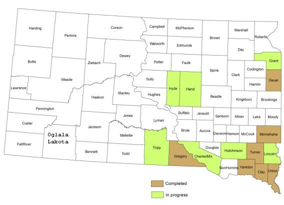
Work began on the project in the summer of 1998 and as work progressed, some modifications were implemented based on the experience gained. The primary change in the work plan has been to exclude test hole locations, except where specific concerns are known to exist regarding test holes. This modification was made based on experience gained in Clay, Minnehaha, Yankton, and Deuel Counties. Drilling sites were found to have rehabilitated to the point where nearly all were unrecognizable in the field. With those test hole sites that were found, there were not problems observed that required any action. These counties included very old drilling sites in Clay County and relatively new drilling sites in Minnehaha County. Therefore, in order to expedite project completion, the decision was made to no longer routinely assess the condition of test hole sites. However, test hole sites where potential problems are suspected are still being assessed in the field.
Thus far, field work has been completed in Clay, Deuel, Gregory, Minnehaha, Turner, Union, and Yankton Counties. Work is ongoing in Charles Mix, Grant, Hand, Hutchinson, Hyde, Lincoln, and Tripp counties. As well sites are visited, the latitude and longitude are determined using a GPS unit accurate to within 1 to 3 meters.
Contacts: Derric Iles, Ann Jensen